Hello readers, this is Louis speaking. Keegan suggested that I should write this post. I was more than happy to do so, given that it's not exactly fair for Keegan to be saddled with the responsibility of taking all the pictures and doing all the writing. Of course, he still took all the pictures on this trip, because frankly, he's a much better photographer than I am, and I think this arrangement suits our differing skill sets quite well. So get ready, because in this post you will experience the majestic writing of the man you used to know only as "that silent, dashing rogue from all the blog pictures, who never does any of the work".
Anyhow, like most of our trips, this one had been percolating in our minds for a while, ever since I noticed something on Google Earth that only a total masochist (or two) would actually want to locate— an odd cluster of rocks in the featureless shrub-steppe where Oregon, Idaho, and Nevada meet.
Anyhow, like most of our trips, this one had been percolating in our minds for a while, ever since I noticed something on Google Earth that only a total masochist (or two) would actually want to locate— an odd cluster of rocks in the featureless shrub-steppe where Oregon, Idaho, and Nevada meet.
Beautiful, right? Of course it is, but let's take a closer look at the spot where those three grayish lines meet up.
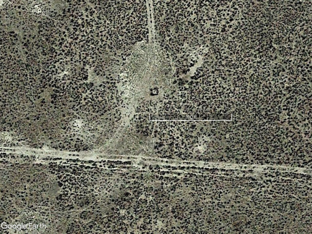
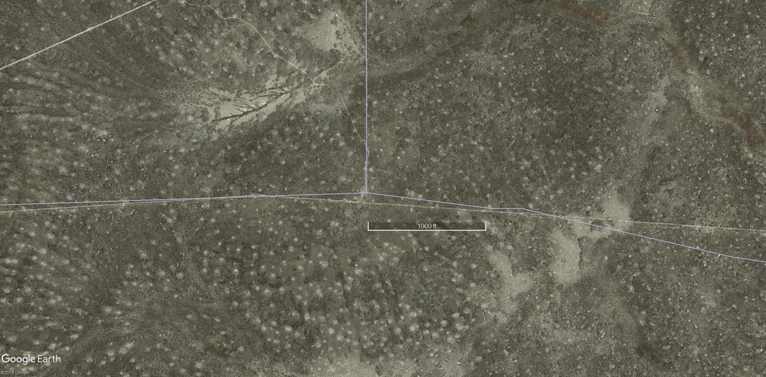
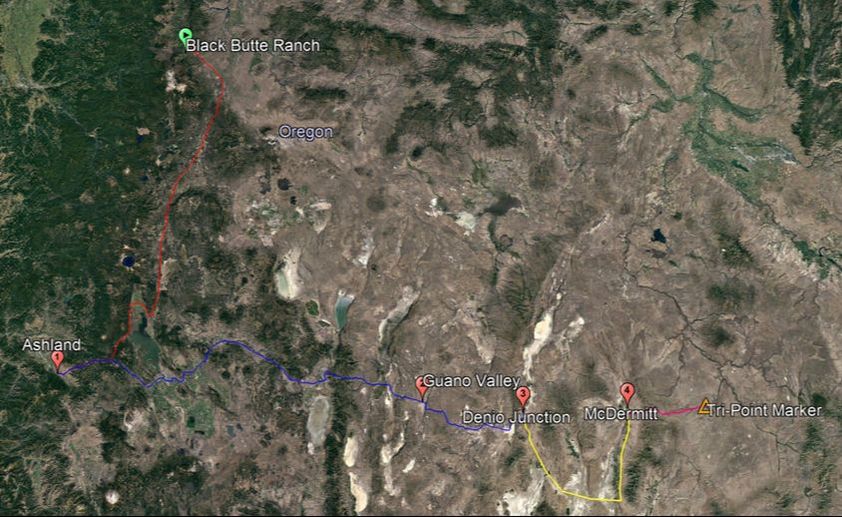
See? There's a thing out there. Not just a thing, a clearly man-made structure at least 5-10 feet across. In far-Southeast Oregon terms, that's a lot. I showed this to Keegan, and from that moment on we were hooked. Once we found ourselves working at Black Butte Ranch in Central Oregon over the summer, we were in a slightly more convenient position to seek out this landmark on one of our signature roadtrips. At this point, I'll include a map of the trip for your convenience. It contains labeled points of interest, to which I will refer.
We set out from Black Butte Ranch on the 28th of July 2017. Our goal lay more or less to the Southeast, so the most spatially convenient route may have taken us through such lovely locales as Burns (no longer the home of anti-public-land militants), Crane (home of the state 1A track champions, I've heard), and Basque (Southeastern Oregon has a lot of Basques, an ethnic group from northern Spain. Go figure.) However, this was not to be, as Keegan and I would not be alone on this trip. We were to be accompanied by Keegan's then-girlfriend Mehana, who was in Ashland at the time, taking classes at Southern Oregon University (also Keegan's university of choice, non-coincidentally). So, we set out to the South from Black Butte, passing through Bend and taking US 95 down to Ashland, the land of kombucha and skinny, goateed men who treat esoteric Buddhism like a fashion accessory. The first leg of the journey was complete, and the second leg was to be very long and arduous, so we spent the night at an apartment belonging to Mehana and several of her friends, all of whom seemed to be doing their best to confirm most people's stereotypes about liberal arts college students. During this portion of our travels, Keegan took no pictures, or at least he didn't supply me with any, which is a tad unfortunate because entering Ashland from the Northeast along Dead Indian Memorial Road (it's a long story) is incredibly beautiful, if a little hard on the brakes due to the steep, ridged hills and hairpin turns.
In the morning, we set out for a real marathon of a drive. That summer, we had the unique pleasure of driving my family's 1997 Chevrolet Suburban, a real beast of car that my father routinely likens to an aircraft carrier, and which I believe has been mentioned before in the blog. May it suffice to say that "The 'Burb", although suffering from its share of age-related mechanical and electrical issues, was (and still is) a trusty and functional vehicle, the sort of car that feels like an old friend. From Ashland we went East, obviously, taking various highways through Klamath Falls and Lakeview, both being pleasant, if almost confusingly nondescript, towns. After stopping briefly in Lakeview, we found ourselves on the Warner Highway, an exceptionally scenic route that winds through some gorgeous high-desert forests, next to the pleasant Camas Creek. As it would turn out, we would not see trees again for quite a while, and our next encounter with running water would be much less than pleasant.
About an hour after leaving the trees behind, we entered the Guano Valley (waypoint number 2), a truly desolate place named after bat droppings, where the heat shimmers like sheets of cellophane rising from the ground and escaping into the sky, because even heat, which isn't even a form of matter, much less a sentient one, doesn't want to live in the Guano Valley. The next time you see a car commercial in which a stubbly, chiseled man abruptly drives his elegant car off the highway and goes flashing across the desert floor like a comet while the fine print tells you not to attempt such a thing, there's a good chance they filmed it in a place like the Guano Valley. Nonetheless, there are two ranches there, which can just barely be seen from the road, and which seem to be in good shape. I cannot begin to explain this.
It is worth noting here that the usual driving arrangements were not observed on this trip. Usually, I drive and Keegan takes pictures. However, on this trip, Keegan finally managed to convince me to let him do some of the driving. As stubborn as I am, I'm certain he was in the right. Although we did all our driving during daylight hours, thus avoiding the risks of driving in the dark on rural highways, I had slept the previous night on a couch that smelled strongly of all manner of things that would upset a priest, so I greatly benefited from the chance to take a quick snooze every hundred miles or so.
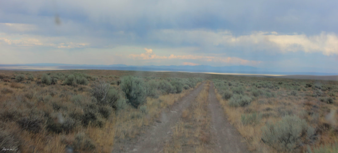
After leaving the Guano Valley by climbing a steep road up the narrow Guano Rim, we found ourselves in a landscape essentially identical to the valley, but minus the rim. That is, empty steppe stretched for miles before us. Such a landscape can only be described so accurately in words, and I think the Alexandrov Ensemble (the Red Army Choir) did a really excellent job describing the steppe in this song, which you may wish to play throughout your reading of the rest of this story. I like it quite a bit myself. It really conveys the emptiness of the landscape. Watch out though, it gets a bit loud around the 1-minute mark, then settles down again, much like the fierce wind in the desolate wastes of Southeastern Oregon.
After leaving the Guano Valley by climbing a steep road up the narrow Guano Rim, we found ourselves in a landscape essentially identical to the valley, but minus the rim. That is, empty steppe stretched for miles before us. Such a landscape can only be described so accurately in words, and I think the Alexandrov Ensemble (the Red Army Choir) did a really excellent job describing the steppe in this song, which you may wish to play throughout your reading of the rest of this story. I like it quite a bit myself. It really conveys the emptiness of the landscape. Watch out though, it gets a bit loud around the 1-minute mark, then settles down again, much like the fierce wind in the desolate wastes of Southeastern Oregon.
Anyway, we drove for quite a while along the Southern border of Oregon before the highway took us south into Nevada. After driving for another hour or so, we found ourselves in Denio Junction, Nevada, the third waypoint on the map. It was certainly obvious to us that we were in Nevada, because Denio's primary building, a small restaurant and motel, was plastered with gaudy signs advertising its slot machines. Needless to say, this encounter did not exactly improve my heavily stereotyped view of Nevada as a desert full of gamblers. We stopped just long enough to take some pictures and use the incredibly dusty restrooms, then left, as time was always a concern.
Not too long after leaving Denio, we found ourselves in McDermitt, NV. McDermitt, like many tiny towns near the tri-state junction, has a bewildering connection to the Basque people of Northern Spain, a quiet and pastoral bunch prone to wearing red berets and hating the rest of Spain. Towns in Southeastern Oregon have names like "Basque Junction", and the McDermitt grocery store offered special Basque meats, which looked absolutely delicious. I've googled "Basque landscape", and I can attest to the fact that their ancestral homeland is a place of verdant pastures, where majestic pine forests cover low, cloud-wreathed mountains. It looks absolutely nothing like the deserts of Malheur County, so there seems to be literally not a single reason why any Basque would want to live there. It seems most of them moved from Spain to California and Nevada, and then moved upwards to Northwestern Nevada and Southeastern Oregon for reasons unspecified. Perhaps they have yet to find out that the Willamette Valley exists.
After buying and filling a large gas canister at McDermitt's primary gas station, we set out for what was to become the most trying part of our journey by far. Up until this point, our trip had been a marathon, a long and steady trek, a test of endurance and patience more than anything else. It was about to become an obstacle course.
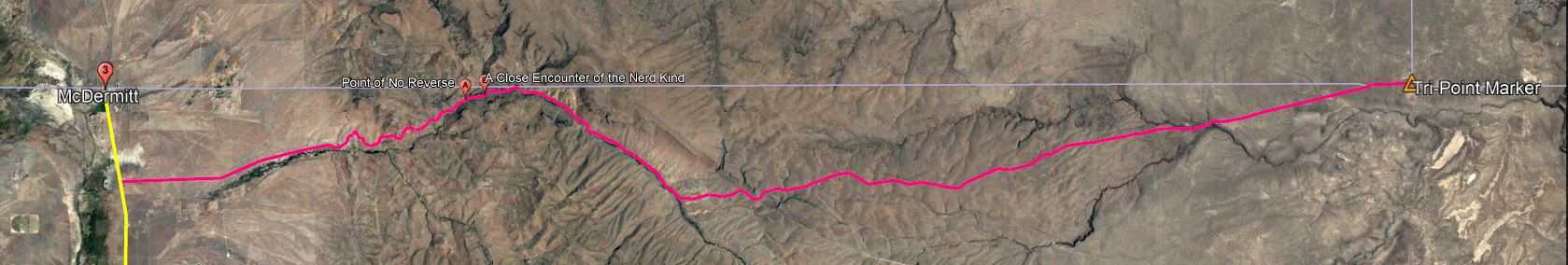
It was here that we were to leave the highway. At this point, I will provide a zoomed-in version of the previous map, focusing on the bright-pink portion at the right. As the image is very wide and not nearly as tall, you may wish to open it in a new tab in your browser so that you can see the additional points of interest which I have marked.
After buying and filling a large gas canister at McDermitt's primary gas station, we set out for what was to become the most trying part of our journey by far. Up until this point, our trip had been a marathon, a long and steady trek, a test of endurance and patience more than anything else. It was about to become an obstacle course.
It was here that we were to leave the highway. At this point, I will provide a zoomed-in version of the previous map, focusing on the bright-pink portion at the right. As the image is very wide and not nearly as tall, you may wish to open it in a new tab in your browser so that you can see the additional points of interest which I have marked.
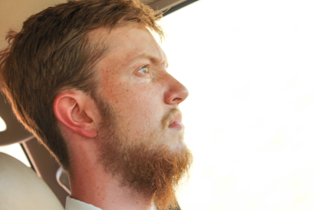
Keegan, much to his credit, had put quite a bit of time into planning this leg of the trip. Our final approach to the corner would take us over 43 miles of extremely rough, often unmarked roads. There weren't many intersections out there, but a wrong turn at any one of them would have been a serious problem. Needless to say, we were all on edge. By "we were all on edge", I mean that Keegan was keeping his cool admirably, Mehana didn't seem bothered or anxious at any point whatsoever during the trip, and I spent the next five hours making this face:
After a brief search, we located the proper road which would take us out of McDermitt to the East. Soon enough, the pavement and buildings ended, and the only signs of civilization were the occasional wire fences and cattle guards on the road.
The road was bad, but that hardly came as a surprise. All things considered, for the first few miles, the road was pretty well-groomed. Despite the many hairpin turns next to cliff faces, things went without incident, right up until we met the East Fork Quinn River. This point is marked on the second map as "Point of No Reverse". We had been driving next to the "River", which was definitely more of a creek at the time, for a while, and now the road had given way to the rocky riverbed. There was little water flowing, but this was the least of our concerns. Essentially, for the next 100-200 feet, the road and the riverbed became the same thing. Before we could tackle that problem, however, we found ourselves in an ever bigger predicament. To meet the riverbed, the road abruptly sloped down at an angle of perhaps 20 degrees. Trust me, that's a lot. Now, the 'Burb is pretty well equipped to handle rough terrain. It's a sturdy car with good tires and suspension. It is, however, made to seat up to eight people, plus cargo, and is thus quite long. After much discussion, we decided to chance it, and when I attempted to slowly ease the car down into the riverbed, its undercarriage began to scrape against the corner of the slope, and we ground quite unpleasantly to a halt. We were "high-centered", meaning that most of the weight of our car was resting on the rocks, rather than on the tires.
During the next few minutes, Keegan put away his camera out of respect, and at the time I'm sure that helped my mood. In retrospect, I would love to have some images of what transpired, but that's 20/20 hindsight for you. Since there are no pictures, I have attempted to recreate the scene in Microsoft Paint.
During the next few minutes, Keegan put away his camera out of respect, and at the time I'm sure that helped my mood. In retrospect, I would love to have some images of what transpired, but that's 20/20 hindsight for you. Since there are no pictures, I have attempted to recreate the scene in Microsoft Paint.
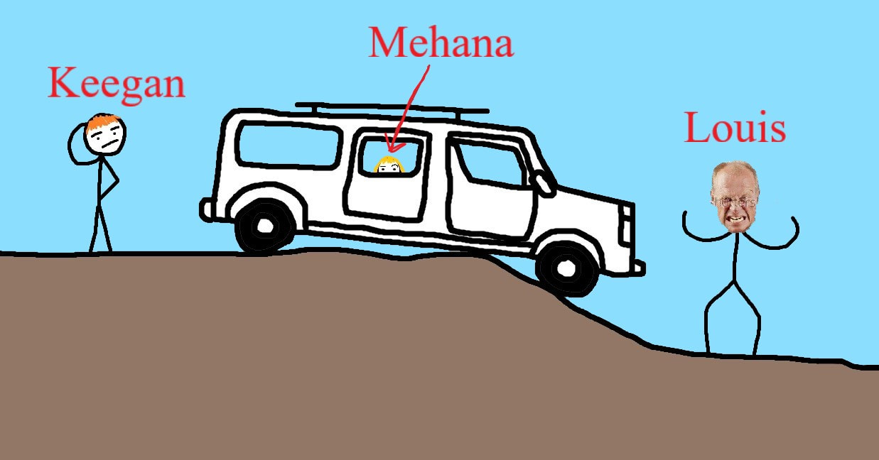
The scene that unfolded, I think, went a long way towards showcasing the comical, Laurel and Hardy-esque nature of the relationsip between Keegan and myself. Keegan, being a carefree sort of fellow, seemed relatively unperturbed and set right to the task of pacing around the car and appraising the situation. I, on the other hand, being the more paranoid of the pair, paced around for a minute or so uttering a stream of lurid profanities and proclaiming numerous times that we never should have attempted such a thing, before finally getting down to the business of actually attempting to fix the problem. Frankly, I think both reactions were justified in their own way. Keegan's reaction was most likely based on the fact that we were a couple of capable guys in good shape and we had plenty of food and drinking water, as well as a GPS, and that such problems are bound to happen every now and then. My reaction was most likely based on the fact that we were 10 miles from the nearest building, and many hundreds of miles from home, we had no cell service, and the 'Burb, which was now possibly totaled, belonged to my family, meaning its loss or damage would affect me more directly. Mehana mostly stayed in the car.
We paced about for a while under the searing midday sun and determined that the car was not in any serious danger; that it, the 'Burb was still drivable. I had feared that some critical component of the car's undercarriage, like the oil pan, had been broken or badly damaged by the rocks. As it turned out, most of the friction was coming from a single large stone directly under the right-side running board, which was now bent at an unhappy angle where the stone was pushing up against it.
After assessing the situation, I made the executive decision that the trip was not to continue. After all, we had no way of knowing how many more potentially car-killing obstacles we would face if we were to continue. Keegan and Mehana both agreed, and at the time I did not notice the thinly veiled undertones of dissatisfaction in their voices. The decision being made, we all piled back into the car. I put it in reverse, slowly gave it more and more gas, and absolutely nothing happened. We could not back up. Having taken years of physics and advanced mathematics, I came to the conclusion that, given these conditions, we ought to go forward instead. Keegan and Mehana, having exactly one option, agreed emphatically with it. Before we could go forward, however, we knew that we would have to remedy the conditions which had prevented us from moving forward in the first place. We put a few minutes into removing the large rock that had been disfiguring the running board, as well as a couple of other troublemakers. This being done, we once again pushed forward, and finally, much to our collective relief, the 'Burb lurched forwards, nearly dipping its bumper into the shallow creek below.
We crossed the creek, which was nothing compared to the previous ordeal, then stopped the car on a high-and-dry portion of the creekbed on the other side, where we got out to take a breather. After all, the scenery was really gorgeous, and only now that my blood pressure had returned to some semblance of normalcy could I take a moment to enjoy it.
We forged ahead with uneasy hearts, fearing the possibility of another run-in with the treacherous East Fork Quinn River. Instead, we had an even more unexpected encounter:
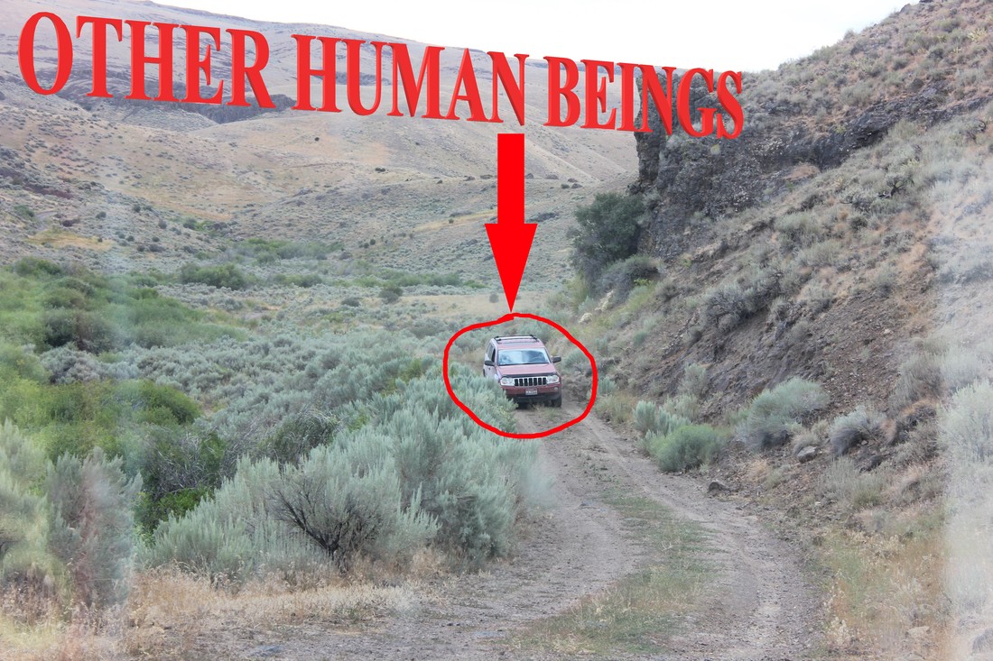
A few minutes after leaving the creekbed and returning to a more road-like stretch of road, we saw, greatly to our surprise, this sight (minus the low-effort editing effects). We had not expected to see another person after leaving McDermitt, and I suspect the drivers of the other car felt the same. Seeing as this was a rare encounter, and inasmuch as we had to slow to a crawl in order to pass each other on the narrow road, we both stopped to see what flavor of insanity had motivated the other party to venture out here. The jeep contained two men, both appearing to be in their late twenties or early thirties. I don't remember their names, but I do remember that they were from Idaho, which stands to reason. It turns out they were playing Ingress, an augmented-reality game vaguely reminiscent of Pokémon Go, although Ingress is actually older by a few years. From my 30 seconds of googling, I've gathered that in the game, there are two teams which compete to gain control of "portals" which are linked to real locations, and portals controlled by the same team will link to each other, forming polygons between them which designate areas of control. Apparently, some psychopath decided that it would be clever to make the tri-point marker, our objective, a portal. These men had journeyed all the way out here to capture it, and I can only imagine they did their faction a great service, because the portal at the tri-point marker is so far away from any other landmark that to link it to another portal would likely bring a truly vast area under their faction's control.
Logistics of Ingress aside, we had a pleasant conversation with the men, which was mostly centered around a discussion of the perils which lay ahead of us on the road. The men gave us no guarantee that we would be able to make it all the way to the marker, given the 'Burb's unwieldy size and length, but they eventually came to the conclusion that the spot where we had previously become stuck was almost certainly the worst point on the road, so if we could make it past that, we would probably be fine. They advised us on how to handle a couple of rough patches up ahead, and cautioned us about several stream crossings we would face, and eventually we thanked them profusely and parted ways.
Logistics of Ingress aside, we had a pleasant conversation with the men, which was mostly centered around a discussion of the perils which lay ahead of us on the road. The men gave us no guarantee that we would be able to make it all the way to the marker, given the 'Burb's unwieldy size and length, but they eventually came to the conclusion that the spot where we had previously become stuck was almost certainly the worst point on the road, so if we could make it past that, we would probably be fine. They advised us on how to handle a couple of rough patches up ahead, and cautioned us about several stream crossings we would face, and eventually we thanked them profusely and parted ways.
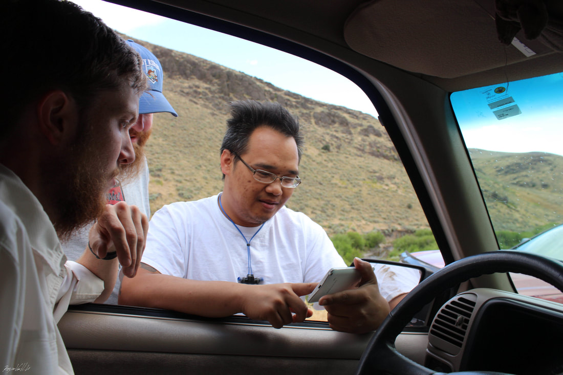
One of the men shows me a video of a particularly rough bit of road ahead
The rest of the drive was by no means uneventful, although the men were right about the "point of no reverse" being the worst part overall. We were only about a third of the way there after we encountered the Ingress-players, and as usual, we were just barely beginning to run out of daylight. So we continued ahead, trying our best to balance caution and speed. At one point about which the men had warned us, we once again faced the trial of driving through the creekbed. We got out and moved some of the larger rocks, and I was stung by a wasp out of nowhere, on the skin right behind the fingernail on my left index finger. Despite that unpleasantry and the extreme bumpyness of the "road", we passed through the creekbed without incident. During the remainder of our drive we faced at least one more rocky creekbed and several actual stream crossings, but we made our way through them, knowing that these obstacles posed very little threat as long as we kept our heads about us. That being said, it seemed that I was the only one who was ever really worried or upset during this portion of the trip. Keegan, I believe, was having a whale of a time, inasmuch as he was going on a fun adventure and his girlfriend was there. Not to imply that he didn't notice the problems we faced or that he didn't care about them; he merely took them in stride, steadfast companion that he was and is.
Eventually, we left the creekbed and the canyons behind, and entered an extremely empty landscape. After many miles in this nothingness, we reached a fence with a gate. Actually, the gate was just a portion of the barbed wire that could be dragged away from its neighboring post to allow a car to pass through. Either way, it was the most advanced technology we had seen in a while, and according to Keegan, it meant that we were close to our goal. Sure enough, we soon reached the critical point of the trip; the point where Keegan's meticulously detailed directions became very unclear, through absolutely no fault of Keegan himself. We had to turn off onto a side road which would lead us directly to the marker, but this side road had no name and barely appeared on any map, inasmuch as it was essentially just a driveway of sorts leading to the tri-point, a dead end with no outlets. According to the map, the marker lay only a fraction of a mile away. But the marker itself was only a foot or two tall, and even the gentlest of rolling hills could easily hide it from our view. If we had taken a wrong turn, as we nearly did several times, we would have passed right by it and possibly found ourselves very lost.
But we didn't. Keegan's navigating skills, and intuition, were sharp as a tack that day (as they are almost every day), and he led us right to the spot. Our joy was absolutely irrepressible. I'm not generally one for theatrics, but I do remember kissing the ground when we finally arrived at the end of the short and unnamed road, where the ubiquitous sagebrush had been cleared in a circle around the monument to allow a car to turn around, or in our case, park for the night and leave enough room for its occupants to pitch a tent.
But we didn't. Keegan's navigating skills, and intuition, were sharp as a tack that day (as they are almost every day), and he led us right to the spot. Our joy was absolutely irrepressible. I'm not generally one for theatrics, but I do remember kissing the ground when we finally arrived at the end of the short and unnamed road, where the ubiquitous sagebrush had been cleared in a circle around the monument to allow a car to turn around, or in our case, park for the night and leave enough room for its occupants to pitch a tent.
As tends to happen on our camping roadtrips, we arrived with just enough time to set up camp before it started to get dark. As usual, I had overestimated how much daylight we would have at our disposal, and how much energy I would have after driving for most of the day, and I had brought quite a bit of raw materials for making food, including flour, rice, spices, etc. I believe I had some goofy idea about making what I referred to as "desert food" — unleavened bread and plain rice. In reality, the sun was starting to set and I was exhausted, so after we set up a fire, I brought out the canned lentil soup, which was magnificent. It tasted like the desert in the best possible way.
When planning our roadtrips, Keegan and I almost always choose destinations that have a lot to explore, and after we arrive we busy ourselves with poking around, taking a bunch of pictures and looking for blog-worthy material. Obviously, this was not the case here. At the intersection of nowhere, nowhere, and nowhere, the tri-point marker was the only thing to be explored, and one needed only to look at it from three different angles in order to have explored it completely. So, we did what any self-respecting campers would do, and burned a fish head as an offering to whatever ambiguous deity had saved our undercarriage back at the creek.
This, obviously, was no ordinary fish head. I believe this story has already been told on the blog, or perhaps on Keegan's Facebook page, so I'll make it relatively brief. On July 4th, I had the day off of work, so I was hanging out around the house, doing laundry and other pleasantly domestic things. In the early afternoon, hours before Keegan was supposed to get off work, he suddenly rolled up the driveway in his work truck and came into the house with a cardboard box. Hoping he hadn't been fired, I met him at the door. His remarkable story went as follows: he was one of the few people working that day— there is always maintenance work to be done, but it was the Fourth of July after all, so the maintenance staff consisted of Keegan, his supervisor, and less than half a dozen other people. Keegan had been given the unremarkable task of clearing debris out of a metal grate at the end of a culvert that ran under a road. Quitea bit of water ran from a lake on one side of the road, through the culvert under the road, and out into a stream on the other side. When Keegan arrived to clean the debris, he found a 25-inch rainbow trout sitting on it, fresher than you'd find at the best fish market. He radioed his boss and told him what had happened. His boss, being a good man who appreciates a good fish, gave Keegan the go-ahead to take the thing home and clean it up before coming back to work. And so I found myself standing at the door, looking down at the largest trout I had ever seen in my life, larger than many salmon I'd seen. Keegan had done the work of "catching" it, so I gutted and cleaned it. Its gills had perfect color, its eyes were shiny and convex, and it showed no evidence of parasites or disease. It must have died a very short time before Keegan's arrival. When Keegan returned from work that evening, he and I concluded that this fish must have been a gift to us from Davy Crockett or Abraham Lincoln or some America-related deity. To further the weirdness, I later realized that the knife I had chosen to gut the fish had the number 1776 stamped into the handle. We ate the fish (which was fantastic) a couple of days later, but we kept the head, because we knew we had to return the favor. So, when we set out to find the corner of Oregon, we brought the fish head along in a bloodstained Tupperware container, which in turn was put in a styrofoam cooler with ice which quickly melted. It was a risky move, but I'd like to think it paid off.
After we had eaten and made our burnt offering, we took part in some photogenic nighttime shenanigans. The clouds cleared up enough to give us a breathtaking view of the stars, and the coyotes seemed to think that the moon deserved a special serenade. Once we finally went to bed (or sleeping bag, if you prefer accuracy), the howling made it a bit hard to sleep, but I wouldn't have wanted it any other way.
After we had eaten and made our burnt offering, we took part in some photogenic nighttime shenanigans. The clouds cleared up enough to give us a breathtaking view of the stars, and the coyotes seemed to think that the moon deserved a special serenade. Once we finally went to bed (or sleeping bag, if you prefer accuracy), the howling made it a bit hard to sleep, but I wouldn't have wanted it any other way.
The next morning, none of us were very hungry and we didn't want to get oatmeal schmutz on the mess kit we had cleaned the night before, so we munched on some snacks and quickly began to break camp and pack up. We knew exactly what obstacles lay ahead of us as we retraced our steps, and we knew roughly how quickly we would have to traverse them in order to make it home on time. Keegan was in no huge rush, but I had to get up at 5:00 AM for work the next morning. We were determined, but nonetheless there was a definite tension in the air. It was like the feeling of an athlete trying to beat his previous best score in a game he knows well.
The drive back was largely uneventful, and much to Mehana's excitement, we got to see some wildlife along the way.
After a while, we left the empty steppe behind, and encountered our old foe: the East Fork Quinn River, hiding in its canyon like the devious beast it is. We knew that attempting to drive directly up the slope would likely be just as problematic as our previous attempt to drive directly down it. So we stopped the 'Burb short of the creek and resolved to figure something out. Eventually, we decided that the easiest solution would be to pile up rocks at the base of the berm, basically flattening out the slope a bit so the car could ease over it without scraping the front or the bottom.
After defeating the hill, we were in the clear, at least as far as physical impediments were concerned, and before long we found ourselves at a cattle gate which I think we all recognized as the boundary of civilization. After the gate, it was only a couple of minutes before we felt the incredibly bizarre sensation of driving on pavement after having driven a cumulative 84 miles on "roads" made of mostly fist-sized rocks.
Arriving at McDermitt, our great sprint began. We set off down the highway, not talking much at first. During the remainder of the trip, the only problem would arise entirely from my own idiocy. Keegan, who had been dozing off in the shotgun seat, decided to climb into the back seat as we sped down the highway. Frankly, I didn't think it was a great idea, and I decided to play a dumb little joke on him. right as his shoulders passed behind my head, I gave the steering wheel a little jerk. Really, it was a very little swerve, but much to my surprise, it was enough to propel Keegan forcefully into the backseat, where his head hit some relatively rigid part of the car. He was (quite justifiably) very displeased, and after a bit of fiery language an icy silence descended on the car. In my defense, I think that it was only by a slim chance that my dumb joke had such an unfortunate outcome. In Keegan's defense, it was an awful thing to do and I should have realized that at the time. Keegan, magnificent man that he is, forgave me immediately and by the time we arrived in Denio we were on fine terms once again. In fact, in a recent conversation, Keegan mentioned that he's almost glad it happened, as it gave a bit of color to the trip. I don't share his view on that, but I think his opinion is the one that counts in that regard.
During the trip, Keegan had decided that he would not immediately accompany me back to Black Butte, instead choosing to stay in Ashland with Mehana for a few days, after which he would, in typical Keegan fashion, find some way back to the Ranch. At this point in the summer, Keegan had quit his job at Black Butte in order to focus his energies on realizing his dream of being a van-dweller. He had been unable to acquire a van anywhere near Black Butte, and as it turned out, his brief stay in Ashland would be an eventful one, and he would return days later in a 1985 Dodge Ram van which would become the focus of one of the more interesting episodes in his life. At the moment, however, I knew none of that. I dropped Keegan and Mehana at Mehana's apartment where we had stayed before, and after saying goodbye to my best friend and his girlfriend, I began the last leg of the journey, the loneliest drive of my life. The setting sun was a deep red behind the wildfire smoke as I, exhausted and with only my thoughts and my iPod for company, guided the old Suburban back up the highway to the house where I would once again find myself left up to my own devices, if only for a while.
I really want to thank you, the reader, for reading this. This blog is a labor of love, and we (mostly Keegan) put a lot of time into it. Speaking of Keegan, I'd also like to thank him for putting up with me— I've been promising to finish this post "this weekend" for about 4 weekends now. Since this was my first time writing a blog post, it was definitely longer than it needed to be and perhaps my language could stand to be a bit less flowery. If you have any comments, feel free to let us know on our Facebook page, Keegan & Louis Adventures. Once again, thanks for reading, and keep exploring!
-Louis